 After spending some time in and at the river, we continued on route 49 to the Mad River Tavern, where we had a great late lunch. If you stick to burgers, sandwiches, and salads, the meals are about $10 per person. The food was delicious and the service was efficient. There is also a little ice cream shop in a small building next to the restaurant that boasts 20 flavors. We didn't get ice cream this time, but we have stopped there before. It's a great alternative to having a full meal out. 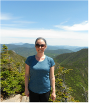
0 Comments
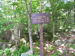
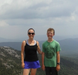
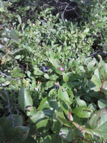
Hike-Swim-Eat Series: North and South Mountain Loop - Pawtuckaway Lake - The Tuckaway Tavern6/6/2015 If you're looking for a nice day trip in southern New Hampshire, you should definitely check out Pawtuckaway State Park, a 5000-acre preserve that spans Deerfield, Raymond, and Nottingham. We live about a 10 minutes' drive from a trail head on the western side of the park, making it a quick and easy hiking option. Within the preserve, there is a state park that includes camping, swimming, canoe and kayak rentals, and hiking trails. There are two small mountains in Pawtuckaway, part of a ring dike, or the remains of an ancient volcano. North Mountain is located on one side of this ring dike, South Mountain on the other. Today we hiked both of the mountains via a loop trail that connects them. Here is a link to a trail map. 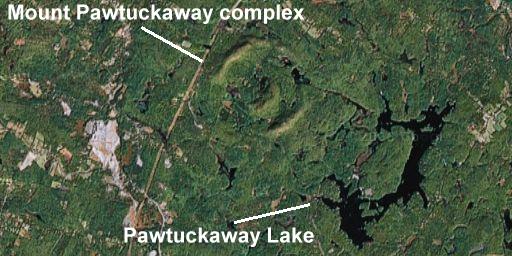 Volcanoes in New Hampshire by MaryAnn McGarry Interestingly, as a ring dike weathers, the process supports the formation of a large number of plant species. This has resulted in this preserve boasting a large number of rare plants, as well as offering several different types of ecological niches. This loop hike takes you through a hemlock forest, an Appalachian oak rocky ridge system, and an oak-sugar maple forest. It never gets monotonous. At the base of North Mountain is an area called Boulder Field, where boulders are scattered across the terrain like gigantic cookie crumbs. Some of them are 30 feet tall. This is a popular place for rock climbers to come and practice different techniques. This longer loop hike features about 7 miles of what I would classify as "ambling" trails, with a few good climbs that will get your heart racing. It's nothing like hiking in the Whites, but it's close to home for me, and lovely. There are some beautiful views from outcroppings of the ring dike as you go along. The summit of North Mountain is fairly anti-climactic, the many outcroppings you pass over on the way up being much more scenic. The summit of South Mountain is more open and features a fire tower that is climb-able, as well. I noticed yesterday that there are blueberry bushes everywhere, and so I completely intend to return again throughout berry season. We park at the Reservation Road trail head. Reservation Road is located off of route 107 between Deerfield and Raymond. Follow it, even after it becomes a dirt road, and you will find a small dirt area with room for cars to park, with signage for North Mountain Trail on either side of the road. We've hiked the loop in both directions. North Mountain is the more vigorous climb of the two, so it depends on if you prefer to do the harder work at the beginning or the end of the loop. The trail is enjoyable and beautiful in different ways, depending on which direction you go. Just like Bear Brook State Park, the trails are not always dependably labeled. I printed out the map and carried it with me, as there are a number of junctions and it can get confusing. Starting at the Reservation Road parking area, jump onto North Mountain Trail. This will carry you over North Mountain, then on an enchanting wander through a hemlock forest. At the bottom of North Mountain, get onto Boulder Trail which passes by Boulder Field and around Round Pond, to join with South Ridge Trail. South Ridge Trail guides you over the summit of South Mountain. From there, continue on South Ridge Trail to Mountain Trail to Tower Road. You can either walk back to the parking area via Tower Road and Reservation Road, or jump back onto North Mountain trail and walk in the woods back to the parking area. After hiking on a hot day, a swim in Pawtuckaway Lake is refreshing. There is no access from the western side of the park, and you'll need to drive about 15 minutes to the main park entrance in order to get beach access. For a nice meal out, check out The Tuckaway Tavern for yummy food and drinks. Expect to wait a little bit for a table at this popular restaurant. 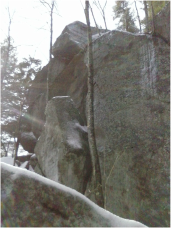 One of the many gigantic boulders in the park. Seen here on a winter hike. 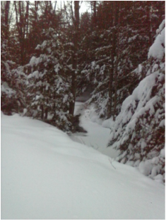 A small stream that runs through the woods along the rail trail where I often walk/ski/snowshoe. A small stream that runs through the woods along the rail trail where I often walk/ski/snowshoe. Well, here in New Hampshire the snow is sure piling up. It's halfway up our front door right now, and I hear there's more on the way. It's cold. Darn cold. So cold that I want to layer up in fleece and long johns and sweaters and wool socks and hide out under my big, fuzzy blanket. All. Day. Long. I also feel like eating baked goods - lots of them - which is the last thing that my body needs. (The banana bread in a previous post was easily devoured within 24 hours, and I'd love to blame it on the men in my home, but I did my fair share of damage.) There is certainly a place for hunkering down with warm stuff and baked goods, here and there, but every day? Not a great plan. So I've been coming up with ways to stay active, get fresh air, and keep building strength despite the cabin fever. Things I can do that are close to home, and not an all-day excursion, but sustainable, daily activities that can be done in an hour or two. I find that I need the following: -A good, moisture-wicking base layer. If you don't have one already, it's worth the investment. I have two sets, but they wash and dry really quickly for daily use. -Warm, squishy hiking socks (mine are a merino wool blend) -Snow pants -A warm fleece and a waterproof shell -Warm hat and neck gaiter, and good gloves and liners -Sometimes goggles, though I don't like them because they leave unflattering lines on my face and, I swear, accentuate my under-eye bags for at least 24 hours. Yes, I'm that vain. Sunglasses often do the trick. To motivate myself to get out in the cold on a weekend day or day off, I will actually put my base layer on in the morning instead of clothes as a way of declaring my intention to be active outdoors. I also do a lot of bribing myself with the thought of the hot shower I'm going to take when I get home, and that amazing post-exercise endorphin high. Good workout, warm shower, endorphin release = my personal trifecta. Oh - and a pot of ginger tea. Any of the following activities are fantastic. I usually end up pulling off drenched base layers afterwards, even though I didn't sense myself sweating during the exercise. Moving through the snow adds a challenging and fun twist to any workout. We live near rail trails which are perfect for walking/skiing/snowshoeing, but last winter, in the absence of rail trails close to home, I went to the golf course in town and made my own tracks there. It was beautiful at sunset. When the boys were little, I actually made a x-c ski track around my back yard and would ski "laps" while they built forts and played in the middle of the yard. Conservation trails work well, or any open field or area that is traffic-free. Breaking your own trail is more tiring in the absence of grooming or snowmobiles, but adds to the quality of the workout. Snow Walking - bare boots - I love snowshoeing and winter hiking. On days that don't allow for a longer excursion, even just a 30-minute walk in the snow will get your heart beating fast and get you a great workout. You don't need any gear outside of some waterproof boots. It's hard to walk in snow - kind of like walking in sand - and is pleasantly exhausting. Snow shoes open up the terrain you can cover, of course, and crampons are important for certain conditions when climbing hills/mountains. But neither is required for a winter walk. Go across a field, or your yard, or venture into the woods. Snowshoeing - So easy - just strap them on and walk out the door. I find that I am more tired and sweaty after a snowshoe than a cross country ski. Thirty minutes is enough to get a very effective workout. The route I've been walking takes me down the rail trail then out onto a property, around a pond, over a stream past a dam, then through a field. It takes about one-and-a-half hours. Late afternoon at sunset is beautiful, but so is early morning. Or try a full moon hike at night. We went out for a 2-hour snowshoe under the full moon a few weeks ago and it was incredible. You can rent snow shoes to try them out - I know that many of the EMS locations in New Hampshire will rent them for the day. If you buy, spend a little extra to get shoes with good, easy-to-use bindings. They make a huge difference. Cross Country Skiing - I bought a whole set (skis, boots, bindings, poles) for $100 at the end of the season back in 2003. I still use the same set. I just broke my pole today, actually, when I took a bit of a spill trying to get up a steep hill. But I've used them nonstop without a single problem otherwise. Probably the best hundred bucks I've ever spent. I have skiied everywhere from groomed trail networks to conservation land to my backyard. Once you have a set, you can make them work almost anywhere - you just need a few inches of snow to get a nice glide going. If you don't know how, go to a ski area and rent a set (usually around $15 for the day) and take a friend who can show you how. I have one of my long-time close friends to thank for my own ability to ski. Shoveling - Not nearly as enjoyable, but still counts as a good workout. Switch arms to get equivalent muscle burn - and to save some strain on your dominant arm. Enough said. Hanging Crunches and Pull Ups - Soon after we moved into our new house, I bought one of those pull up bars that can be put up in a doorway. It's become a family tradition to do a few pulls ups at random times throughout the day. I have also been doing hanging crunches and oblique twists in between other activities - throw in a load of laundry, do 20 hanging crunches. This is keeping my upper body and core strength up, even though I am less active than I would be in warmer weather. Yoga/Deep Stretching - All of the movements in the snow really work the hips, quads, and knees. Stretching out after is so important to avoid injury. I have pretty much eradicated my left knee and hip pain by doing long, deep stretches of my hips, legs, and lower back. My favorite way to do this is through a variety of yoga poses. Sometimes I make it to a class, but more often I just flow through poses that I am familiar with. I have always considered stretching secondary to getting the more intense aspect of my workouts, but, particularly as I get older, I am recognizing that it's actually the stretching that is important, and the rest of it is just the icing on the cake. 
It's a gorgeous, sunny afternoon. Our midterm schedule at school this week means I get home at 1:30 rather than the usual 4:30 or 5, which means that I have the luxury and privilege of a few hours to spend in winter afternoon sunlight, even though it's a weekday. Which means that I will most definitely spend them outside.
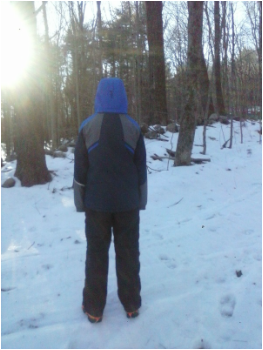
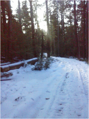
My initial thought is to go alone - I love the solitude that a long walk affords - but I take a look at my boys, all arms and legs and deep voices these days, and I figure they need the afternoon sunlight as much as I do. If not more. Teenage boys gulp down resources - food, water, love, laughter - with a voracity that continues to surprise me. I like to feed those appetites as much as I can, while I can. I goad them into joining me. In our new home (which I love in a disturbing, obsessive way), we live about a 12-minute drive from trail heads at two local state parks, Pawtuckaway and Bear Brook. Both offer acres upon acres of wooded wilderness, swimming holes, streams, and soft, forest-y silence. This weekend, a long weekend, I finally took the time to print out PDFs of trail maps of both locations. When I look at a trail map, any trail map, I get that kind of excited-kid feeling, seeing all that there is to explore. I love that someone has taken the time to build trails, maintain trails, and map it out. Seeing it laid out on paper makes me want to go. Now. I plan a loop through Bear Brook, which will take us up Hall Mountain, a hill, really, at 980 feet. But still. Time in the woods is time in the woods. We pack lightly for this short walk - water, layers, gloves and crampons. Rather than grabbing my fully-equipped pack, I get lazy and grab the closest one, a decision I'll kick myself for later. Everyone got a new set of crampons for Christmas this year, and the boys haven't tried them out yet. The boys also both have new hiking boots to break in, and I figure better on a short afternoon walk than on our first spring hike in the Whites. I anticipate we'll be gone for two hours at the very most, including the drive. The boys got used to hiking 10- and 15-mile trails with tons of elevation gain this summer. An amble in Bear Brook will be a breeze. And I tell them so. The map I'm using is for mountain bikers. It has contour lines and details the network of biking trails that run through the park. Snowmobilers also frequent the park in the winter, so I'm confident that there will be clear, broken trails. And there are. We park on Podunk Road (yes, it's really named that) and head up the Hall Mountain trail. The crampons come in very handy. The snow is packed and slightly soft, but there are extended icy patches as well. The route up to the summit is a breeze, and we are there in well under 30 minutes. It's about 3:00 when we summit Hall Mountain. There are two choices from here - head back the way we came - a guarantee - or continue on the loop. My oldest and I look at the map together and decide to continue on the loop that I had originally considered, even though the trails aren't marked with the blazes that I've grown accustomed to. I have directional issues (to say the least), and I am trying to learn to read maps accurately, but also appreciate having another source showing me that I'm on the right path. We evaluate where the sun is, and where the trail heads, and decide to continue on the loop. It's gorgeous as we walk through the woods. We see bear, moose, and deer tracks. We separate a bit on the path, each of us getting into our own walking rhythm and our own thinking space. We check in with each other once in a while, but it's a wonderful time of communal solitude. The woods are silent, the occasional tree creaking, the crunch of snow and ice under crampons are the only sounds. As the sun sinks lower in the sky to the west, a golden light filters through the trees, lighting up the barren landscape in a way that I find both evocative and enticing. At the next trail junction, we stop and re-evaluate: map, sun, energy level, estimated sunlight left. Again, the question of do we head back the way we came (the certain path) or continue on the loop (which looks convincingly reasonable). There are no blazes, still, but a well-broken trail. We continue on the loop. I'm getting a bit nervous now. Mileage-wise, on the map, we are under 2 miles from the car. It's only 3:30. We move at a pretty good pace when we hike, and, without significant altitude changes to deal with, I am confident that we can be there in well under an hour. But still. I'm a mom, and I'm out here with my kids. They may outsize me in every way at this point (the youngest recently surpassed me in both height and weight), but I still feel that maternal responsibility. At the next junction, the trail splits. There is a smaller trail that cuts a big corner and gets us back to the parking area faster, or a main trail that will take longer. We see the smaller trail off to the right with a sign at the start of it. It seems straight forward. It aligns with what is on the map, and where the (continually sinking) sun is. We head down the smaller trail. We've gone about 15 minutes when the voices of doubt start to enter. It feels to me like we are headed southwest when we should be headed southeast. Since I didn't bring my own fully-equipped pack, I don't have a compass. Or head lamp. Or fire starter. All of this weighs on me. "Stupid, stupid, stupid," I think, plus some more colorful words. The trail, which is broken, is not marked with blazes, so it's impossible to know at this point if we are on the actual trail or just following someone else's steps. But if it is the right trail, we are almost to the road. Almost. Just another 5 minutes, I think. We must be close. I don't want to alarm the boys. I don't want to retrace our steps. My heart starts to beat faster. We come upon a body of water to the left and stop to re-evaluate. I'm watching the sun sink further down. We are in deep forest now, and I'm picturing us becoming a news story. When we look at the map, I see that we are on the wrong side of the body of water. And there are two potential bodies of water it could be. And I'm not sure which it is at this point - I'm so turned around. The trail could be just over there, or we could be in the middle of the park. My oldest weighs in on his opinion, and make a call together. We need to go back. Quickly. I know if we can get to the main junction and trail that we can follow a larger trail back to the car. Even if it's dark, that's better than being stuck on this little trail in the woods. At this point, we've already walked over 4 miles in snow with crampons, which is tiring. In terms of fitness levels, I'm definitely most fit, and my older son is fairly fit, but my youngest hasn't hiked farther than 2 miles since the fall. This is a physical challenge for him. We need to move fast, but I don't want to be too alarmist. I move very quickly back on the small trail. I'm afraid that if, worst case scenario, it gets dark while we're on this trail, we'll lose our footprints. The only light I have is on my cell phone, as I didn't bring the aforementioned properly stocked pack. I figure if I'm at the junction, I can guide them back to the main trail using my voice and light from the cellphone. I'm relieved to get back to the junction. Even though the first leg of the main trail isn't labeled, it appears on the map that it has to be Bear Hill, the trail we're looking for. It's about a mile on this trail back to the Podunk Road trail that will get us back to our car. We still have over 2 miles to cover in increasing darkness, but I feel better being a major trail and knowing that we are headed in the right direction. I take a deep breath and relax. We still need to move quickly, stay warm, and be safe. But we're on the right trail. As the sun sets further into the sky behind the trees, the sky starts to glow a beautiful, ephemeral periwinkle color. A crescent moon comes up. We can see a few planets. In the distance, evergreens form a black silhouette against the glowing pastel sky. I stay relaxed, and so the boys stay relaxed. We talk. I review chemistry with my younger son, who has a test tomorrow. We make our way through some dark woods, but we have enough residual daylight to see our trail. Nearly 45 minutes later as we finally approach the car, I say to my boys "Now don't you wish you had a mom who just came home from work and watched TV?" I chuckle; they don't. My oldest says, genuinely, that this is the most enjoyable thing he's done in a long time. My youngest just wants to know if he can play Destiny (a Playstation game) when he gets home. Classic. I committed all of the classic blunders of unprepared hiking, and I feel foolish for that. But we were okay, I had contingency plans, and it ended up to be a good object lesson on several counts: Be prepared for the worst. Always. Don't let someone else's steps override your instincts. Sometimes, in some circumstances, the well-traveled road is the better choice. And most of all, my boys rock. What a privilege it is to be raising them. I hope I'm doing right by them. Hike-Swim-Eat Series: Moosilauke-downtown Woodstock waterfalls-Woodstock Inn Station and Brewery9/27/2014
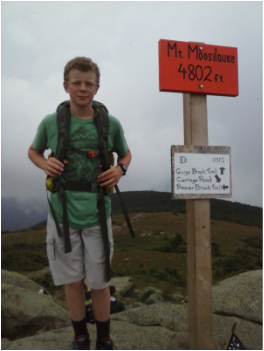
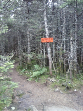 Moosilauke is a fun and very rewarding climb. You get the high alpine experience with a relatively easy, gentle climb. We opted to do a loop, summitting both South Peak and Moosilauke in the process. There are a number of trails up Moosilauke. Our route was about 8 miles and very manageable. I think this hike would be accessible even for families with younger kids - maybe as young as third grade.
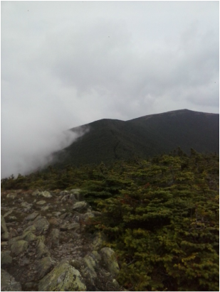
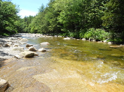
We started at the Ravine Lodge. To get there, take 93 to exit 32. Follow 112 west for about 3 miles to route 118. Follow 118 for about 7 miles to Ravine Road. Ravine Road is a dirt road that will take you to Ravine Lodge. There are bathrooms and a place to fill water bottles at the lodge. From the Ravine Lodge, we took Snapper to the South Peak, then hiked over to Moosilauke, then continued on the Carriage Road and finally back to Gorge Brook Trail for the descent. It was an overcast day so we didn't have great views, but the atmosphere on the summit was still really cool. It's a long walk above treeline, with a huge summit area for hanging out and having a snack...or a nap. It feels a lot like being on top of the Lafayette Ridge or the Presidentials, but is an easier climb, in my opinion. After the hike, we drove back on 112 east until we hit route 3, which runs through Woodstock. Woodstock is one of the cutest towns I've ever seen, full of New England charm and mountain culture. Near the center of town is a charming inn and brewery, the Woodstock Inn Station and Brewery. This has been one of my favorite pit stops over the years after a day of cross-country skiing or hiking up north. Across the street from the inn is a small town park. This is a great place for a quick plunge or ride down a natural waterslide in the Pemigewasset River. It's chilly, but refreshing. Just follow the crosswalk across from the inn, then the path to some stairs. There is nowhere to change or use a bathroom, so you need to get creative in your car, or, if you're lucky enough to be female, purchase and use a "changing room skirt", which provides a clever and effective way to change just about anywhere. Mine came in handy multiple times this summer. And even though there are no facilities,there is fresh, cool water, and flat, sunny rocks to lie on to warm up after a quick dip. The menu at the Brewery is extensive, with a little bit of everything. The men all got burgers, and I got an order of what were, in my opinion, the best sweet potato fries ever, and a fantastic Greek salad. As the name would imply, you can get beers that are brewed on site, as well as fresh-brewed root beer. In my pre-gluten free days, I used to enjoy getting a flight of beers to sample the different brews, and I would highly recommend this route if you enjoy beer at all. Pricing is moderate - plan on $15 per person if you stick to sandwiches/burgers/salads. I've never had a disappointing meal here.
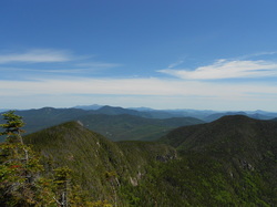
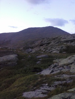
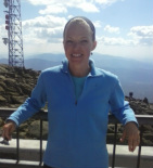
I just completed something I am very proud of: a 2-day, 20-mile solo hike. I stayed overnight in an AMC hut, so I sort of cheated, but it was 2 days of carrying my own 25-pound pack, no one to talk to, no one to take care of...just me, my thoughts, lots of granite, and ridiculous amounts of beauty. I was in need of some thinking time and space, and there is nothing more therapeutic for me than doing that to the cadence of hiking feet. 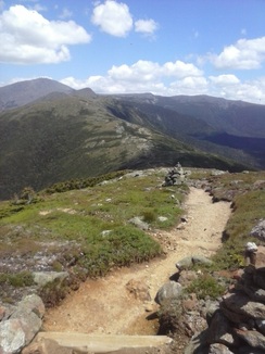 Nine years ago, I did this hike with one of my closest friends in honor of her 30th birthday. I figured it would be a good first solo hike for me, as I was familiar with the trail and had done it successfully before. It is also one of the most beautiful places I have ever been, and very peaceful. The Crawford Path starts in Bartlett, NH on Route 302 and is the oldest maintained trail in the US, built in 1819. It is 8.9 miles from the parking lot to the AMC hut named Lakes of the Clouds, which was where I had reserved a bunk for the night. I love the Crawford Path for several reasons. One is that it is a gradual climb (by NH standards) to the first 4,000 footer that you get to summit. And if you choose to, you can summit three on your way to the hut - Mt.Pierce, Mt.Eisenhower, and Mt. Monroe. And also, for much of it, you are above treeline and walking on a ridge. It is other-worldly up there - mossy and rocky with views in every direction. Summitting the 3 southern mountains on the way is more like taking short, rock-scrambling detours up to breathtaking views than anything, as the path already has you at high altitude. I'll be honest - I was nervous. I made a thorough packing list. I brought a map and compass, an emergency whistle and pepper spray, matches, rain gear, a down coat (it was 80 in the valley when I started out), lots of calories, matches, a flashlight...I was prepared for everything. (I didn't use any of it, except for the calories and down coat, but only to snuggle up as I sat on a rock to watch a sunset that night). I had never hiked alone before, and this was exciting but a little nerve-wracking. Mainly, I'm afraid of running into a bear. Irrational, I know. But still. The trail starts in the luscious New Hampshire forest and ambles alongside a river, then a waterfall, then continues higher into a thicker forest. Soon the trees start getting shorter, springs of water run across the trail, the moss carpets the forest floor, all sorts of interesting flowers blooming among the green moss. After a few miles of climbing, the higher alpine forest begins with even smaller trees and larger swaths of granite. I hike differently now than I did 9 years ago. I have a very sensitive knee, so I find I take smaller steps. I'm more contemplative. I take my time. I don't rush. I consider more carefully where I put my feet and how I bend my knees. I know that the more cautious I am, the more longevity I will have on the trail. I made great time, but also avoided injury. I got to the hut in about 4 hours. I lightened my pack, then I headed up to summit Mt. Washington for the 6th time in my life. It's 1.4 miles to the summit from the Lake of the Clouds hut. It's a long, granite staircase to the top, but it's a relatively gentle climb, and breathtaking views are a welcome distraction.
I hung out at the summit for half an hour or so, then headed back down to the hut. My knee was starting to complain a bit. Dinner was served at 6, and around 8 a fabulous sunset began. I found a comfy patch of granite to sit on, wrapped up in my down jacket, and watched the sun sink into the sky over a panoramic view of the valley. It was breathtaking. The rest of the evening was spent reading, writing, thinking, and dreaming. From my bunk, I could watch the stars - thousands and thousands of them - move across the sky. (And I did watch for hours, as there were at least 6 people snoring like freight trains in the room with me.)  I hiked out the next day, the same way I came in. I had another clear day with sweeping views the entire way. So much beauty - I could hardly stand it. Views to every side. By the time I got to my car, my feet were yelling, my body was tired of having 25 pounds hanging on it, and I was ready for a warm shower and a little relaxation.
But it didn't matter. I found the solace I was looking for in this time alone, and in the beauty I drank in, and in the accomplishment of doing this on my own. I would highly recommend.  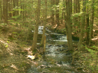 I appreciate the gym, the dependable asphalt of the roads around my home, and my handweights and yoga mat for the daily, maintenance-style exercise I need to do to stay strong, flexible, and fit. But it does get tedious and boring some weeks, and sometimes one just needs to get out of town. Yesterday, upon seeing a bit of sunshine after a loooonngg week of rain, we made a spontaneous decision to head to the White Mountains for a hike. We have woods all around us and certainly could have hiked somewhere closer to home. (For those of you who are local to southern New Hampshire, Wason Pond in Chester, Pawtuckaway in Nottingham, and the fire roads around Lake Massabesic all offer great, woodsy walking, biking, and riding.) But it's hard to beat the White Mountains.
There is something magical that happens once we get north of Plymouth. The landscape continues to change, the air feels cleaner, and I relax. Maybe it's a conditioned response: the only time I head that far north is for recreational purposes. But it feels great, and amazingly, in about 1 hour and 15 minutes, we can be in Franconia Notch, Mt. Lafayette and its neighbors towering above us to the right, and Canon Mountain and Profile Lake on the left. It's gorgeous. Yesterday we opted to hike Lonesome Lake, highly family friendly, with rewarding views at the top. It's only 2.4 miles round trip, making it non-torturous for small children, especially a certain 9-year-old, and therefore for us. It's a moderate climb, with an elevation gain of maybe 800-1000 feet. At the top is a beautiful lake and an AMC hut. There are great picnic spots, and, on a clear day like yesterday, a breathtaking view of the Lafayette Ridge. We hiked the loop around the lake, adding about a mile to our total distance. The loop trail is mostly boardwalk made of hewn logs, and it takes you through a beautiful ecosystem comprised of wetlands and lush, mossy forest. There were many nerdy family moments as we discussed the biology behind everything we were taking in. A huge pile of moose scat was one of the highlights. :) Hiking uphill is a highly beneficial activity. It utilizes some of the largest muscle groups in the body, making it a great calorie burn. It tends to be interval-like naturally - a long, straight, steep climb, stopping for 60-90 seconds to catch your breath, then climbing again - which cranks up the fat burn and keeps your metabolism elevated for hours after the activity. If you carry a pack, you add on a nice upper body workout to your activity. Going down the hill uses a whole new set of muscles, giving you a great total body workout. Another benefit to hiking? Just being in the forest. Mark Sisson wrote about a concept called forest bathing a while back - it's an intriguing concept, and worth a read. Check it out here. As it turns out, just spending time in the forest reduces stress, even long term. Think of it like sunbathing, but in a forested environment. Even just 20 minutes appears to confer benefits! And, of course, these benefits could be gleaned from a more local, woodsy environment. |
AuthorI'm Emily. I currently work in online education management, but I also have a Masters degree in Nutritional Sciences (my true passion). In addition, I am a mom, cook, avid reader, novice gardener, and enjoy all kinds of outdoor activities. On my blog, you will find articles on food, fitness, weight management, and eating issues. ALL recipes on my blog are gluten-free. Many are low-carbohydrate. Most are grain free. Enjoy! 
Categories
All
Archives
June 2019
|